- Title
- Zalesienia priorytet 2 - projekt korytarzy ekologicznych 2005
- Abstract
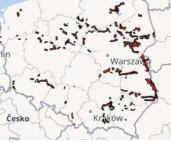
Priorytet 2 obejmuje wytypowane odcinki korytarzy pełniące funkcje połączeń alternatywnych w miejscach o szczególnym znaczeniu dla ciągłości sieci korytarzy w skali krajowej. Odcinki te powinny być również objęte programem zwiększania lesistości w możliwie niedługim czasie, w zależności od możliwości finansowych.
- License
- Attribution 4.0 International (CC BY)
-
+ You are free to:
+ Share — copy and redistribute the material in any medium or format
+ Adapt — remix, transform, and build upon the material for any purpose, even commercially.
+
+ Under the following terms:
+ Attribution — You must give appropriate credit, provide a link to the license, and indicate if changes were made. You may do so in any reasonable manner, but not in any way that suggests the licensor endorses you or your use.
+ No additional restrictions — You may not apply legal terms or technological measures that legally restrict others from doing anything the license permits.
+ For more info see https://creativecommons.org/licenses/by/4.0/. - Publication Date
- Dec. 31, 2020, 9:37 a.m.
- Type
- Vector Data
- Keywords
- korytarze ekologiczne zalesienia
- Category
- Environment
- environmental resources, protection and conservation. Examples: environmental pollution, waste storage and treatment, environmental impact assessment, monitoring environmental risk, nature reserves, landscape
- Regions
- Global, Europe, Poland
- Approved
- Yes
- Published
- Yes
- Featured
- No
- DOI
- None
- Name
- MRIPAS
- openforestdata@pb.edu.pl
- Position
- None
- Organization
- None
- Location
- Voice
- None
- Fax
- None
- Identification Image
-


- Spatial Extent
- ---
- Projection System
- EPSG:4326
- Extension x0
- 14.384887695312500
- Extension x1
- 24.099094390869100
- Extension y0
- 49.535793304443400
- Extension y1
- 54.197921752929700
- Language
- Polish
- Temporal Extent
- Jan. 1, 2005, midnight - Dec. 31, 2005, noon
- Supplemental Information
Nie umieszczono informacje
- Spatial Representation Type
- vector data is used to represent geographic data
- Name
- MRIPAS
- openforestdata@pb.edu.pl
- Position
- None
- Organization
- None
- Location
- Voice
- None
- Fax
- None
- Link Online
- /layers/geonode_data:geonode:zalesienia_priorytet2_wgs84
- Metadata Page
- /layers/geonode_data:geonode:zalesienia_priorytet2_wgs84/metadata_detail
- Thumbnail
- Zalesienia priorytet 2 - projekt korytarzy ekologicznych 2005.png
- Remote Thumbnail
- Zalesienia priorytet 2 - projekt korytarzy ekologicznych 2005.png
- Legend
- Zalesienia priorytet 2 - projekt korytarzy ekologicznych 2005.png
- Excel
- Zalesienia priorytet 2 - projekt korytarzy ekologicznych 2005.excel
- CSV
- Zalesienia priorytet 2 - projekt korytarzy ekologicznych 2005.csv
- GML 3.1.1
- Zalesienia priorytet 2 - projekt korytarzy ekologicznych 2005.gml
- GML 2.0
- Zalesienia priorytet 2 - projekt korytarzy ekologicznych 2005.gml
- Spakowany Shapefile
- Zalesienia priorytet 2 - projekt korytarzy ekologicznych 2005.zip
- GeoJSON
- Zalesienia priorytet 2 - projekt korytarzy ekologicznych 2005.json
- Zipped Shapefile
- Zalesienia priorytet 2 - projekt korytarzy ekologicznych 2005.zip
- PNG
- Zalesienia priorytet 2 - projekt korytarzy ekologicznych 2005.png
- Zalesienia priorytet 2 - projekt korytarzy ekologicznych 2005.pdf
- JPEG
- Zalesienia priorytet 2 - projekt korytarzy ekologicznych 2005.jpg
- Original Dataset
- Zalesienia priorytet 2 - projekt korytarzy ekologicznych 2005.zip
- OGC WFS: geonode Service
- Geoservice OGC:WFS
- OGC WMS: geonode Service
- Geoservice OGC:WMS
- Name
- MRIPAS
- openforestdata@pb.edu.pl
- Position
- None
- Organization
- None
- Location
- Voice
- None
- Fax
- None