- Title
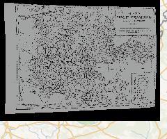
- Mapa Puszczy Białowieskiej z 1887 roku, georeferencjonowana
- Abstract
Mapa Puszczy Białowieskiej ułożona przez K. Drymmera (z: Błoński F., Drymmer K., Ejsmond A. 1888. Sprawozdanie z wycieczki botanicznej odbytej do puszczy Białowieskiej w lecie 1887 roku, Pamietnik Fizjograficzny 8: 59-155)
- License
- Not Specified
-
+ The original author did not specify a license.
- Publication Date
- March 24, 2021, 10:57 a.m.
- Type
- Raster Data
- Keywords
- GeoTIFF WCS
- Category
- Imagery Base Maps Earth Cover
- base maps. Examples: land cover, topographic maps, imagery, unclassified images, annotations
- Regions
- Global, Europe, Poland
- Approved
- Yes
- Published
- Yes
- Featured
- No
- DOI
- None
- Name
- MRIPAS
- openforestdata@pb.edu.pl
- Position
- None
- Organization
- None
- Location
- Voice
- None
- Fax
- None
- Identification Image
-


- Spatial Extent
- ---
- Projection System
- EPSG:4326
- Extension x0
- 23.324398342000000
- Extension x1
- 24.585598342000000
- Extension y0
- 52.423480252000000
- Extension y1
- 53.000280252000000
- Language
- Polish
- Temporal Extent
- Jan. 1, 1887, 11:57 a.m. - Dec. 31, 1887, 11:57 a.m.
- Supplemental Information
Nie podano informacji
- Spatial Representation Type
- grid data is used to represent geographic data
- Name
- MRIPAS
- openforestdata@pb.edu.pl
- Position
- None
- Organization
- None
- Location
- Voice
- None
- Fax
- None
- Link Online
- /layers/_1887_wgs84_proj:geonode:a__1887_wgs84_proj
- Metadata Page
- /layers/_1887_wgs84_proj:geonode:a__1887_wgs84_proj/metadata_detail
- Thumbnail
- Mapa Puszczy Białowieskiej z 1887 roku, georeferencjonowana.png
- Remote Thumbnail
- Mapa Puszczy Białowieskiej z 1887 roku, georeferencjonowana.png
- Legend
- Mapa Puszczy Białowieskiej z 1887 roku, georeferencjonowana.png
- GeoTIFF
- Mapa Puszczy Białowieskiej z 1887 roku, georeferencjonowana.geotiff
- GZIP
- Mapa Puszczy Białowieskiej z 1887 roku, georeferencjonowana.x-gzip
- PNG
- Mapa Puszczy Białowieskiej z 1887 roku, georeferencjonowana.png
- Mapa Puszczy Białowieskiej z 1887 roku, georeferencjonowana.pdf
- JPEG
- Mapa Puszczy Białowieskiej z 1887 roku, georeferencjonowana.jpg
- Original Dataset
- Mapa Puszczy Białowieskiej z 1887 roku, georeferencjonowana.zip
- OGC WCS: geonode Service
- Geoservice OGC:WCS
- OGC WMS: geonode Service
- Geoservice OGC:WMS
- Name
- MRIPAS
- openforestdata@pb.edu.pl
- Position
- None
- Organization
- None
- Location
- Voice
- None
- Fax
- None